Showing posts with label geography. Show all posts

Friday, June 8, 2012

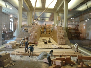
Awesome Diorama of the National Road


Yesterday in Norwich, Ohio (about 7 miles east of Zanesville) I visited the National Road/ Zane Gray Museum. The National Road exhibit had an awesome diorama that stretched around a large room. I couldn't resist using my cheap point and shoot camera to make a video to document it.

In the center of the room, they had parked a Conestoga wagon. These massive vehicles were the semi-trucks of their era, and nearly every manufactured or imported good in early 19th century Columbus came over the mountains from Philadelphia in one of these:
Conestoga wagon dating to 1800. Specialized for mountain travel, Conestogas were never used much in the Great Plains further west.

Wagons normally traveled in trains like this. By the 1830s many elegant stone bridges like this one had been constructed. Some of them were built in an odd S shape, for which no one has a ready explanation.

The mule or horse teams were fed using the long trough that stowed on the back of the wagon.


Thursday, May 31, 2012

Travelling the Old Roads of Ohio

This is a long overdue update for my blog.


I’ve been meaning to take some day trips out from Columbus (geographically, near the center of Ohio) to visit some museums and historic sites in the region. When the weather first turned fair after our short winter this year, I set out to find a few such sites by following General Harrison’s military road. One of these roads runs roughly north from Columbus. I followed State Route 23 through Delaware and Upper Sandusky, and then turned onto Route 53 through Tiffin, Fort Seneca, Old Fort, and finally Fremont.

This route corresponds to one of the military roads that General Harrison built in 1812-13 to supply his forces. 200 years ago Delaware was a small settlement, astride the upper Whetstone (Olantangy) River. Upper Sandusky became the army’s main depot. The friendly Wyandot Indians here supported the United States during the war, and were rewarded by the construction of a grist mill—there is still an old water-powered mill on the site.

DSCF0092

A scaled down “blockhouse” on the site of Fort Seneca in Old Fort, Ohio.

Tiffin did not exist but a small post called Fort Ball (after James V. Ball of the US Dragoons) was built there to protect the supply convoys. Fort Seneca is a small town that was founded sometime during the 19th century—its neighbor to the north, the even smaller hamlet of Old Fort, Ohio, was the actual site of Fort Seneca. During the late summer of 1813, this was the site of Harrison’s main encampment. Route 53 north of Tiffin runs along the Sandusky River, which eventually empties into a wide muddy bay at the lakeshore. A few miles north, in Fremont Ohio (then called Lower Sandusky), Fort Stephenson was built to guard the fords of the Sandusky, near the highest point that sailing vessels could ascend the river from the lake.

DSCF0157

Old Betsy: the iron six pounder with which Major George Croghan defended Fort Stephenson against a British attack in 1813.

DSCF0158

The sidewalk here is roughly the same place where Lt. Colonel W.C. Shorrt led the grenadier company of the British  41st Regiment into the ditch surrounding the Fort Stephenson. Croghan used a six pounder loaded with canister or case shot to sweep the ditch, killing the Colonel and many of his men. See an earlier blog entry about the battle.

battle of fort stephenson

The site of the fort itself is now a public library.


The history along these roads is commemorated by roadside plaques and the names that christen businesses and streets. Tiffin is home to a large Civil War museum (http://www.acwmo.org/). Fremont is the site of President Rutherford B. Hays’ estate, and presidential library (http://www.rbhayes.org/hayes/). Deep within the Hays museum there are actually some artifacts from the War of 1812, including a bronze six-pounder that was originally captured from the British during the Revolution—then changed hands when Detroit was captured and retaken during the war. There’s even a small chance that General Henry Procter brought this same piece with him to bombard Fort Stephenson during the August 1813 siege.

DSCF0130

The old six pounder—a prize of both the Revolution and the War of 1812.

DSCF0096

A DC-3 at the airstrip along Route 53, south of Fremont.

DSCF0145

The Hayes museum also contains many relics of the 1900 Boxer Rebellion in China, captured or looted from Tianjin or Beijing. This bronze cannon is engraved with Mongolian characters.

DSCF0144

DSCF0111

“Peace and Friendship” an Indian medal exhibited with the Thomas Jefferson artifacts in the Presidential Library. Jefferson sought to create an “empire of liberty” at the expense of tribes who refused to adopt the agrarian lifestyle of the whites. Even tribes that did, like the Wyandots at Upper Sandusky, were later forced to move during the Jackson administration.

DSCF0210

The Indian Mill near Upper Sandusky. A gift to the Wyandots after the War of 1812, the mill went into private hands after the tribe was forced to relocate beyond the Mississippi during the 1830s. The existing structure dates from later in the 19th century.

One of the artifacts in the Hayes Museum was a silver Indian medal signifying one of the treaties between the United States and the American Indian nations during the Jefferson Administration. It brought me full circle, having passed the site of the Wyandot Reservation in Upper Sandusky and the Seneca Town where Harrison established his fort—two groups of friendly Indians who disappeared from Ohio during the 19th Century.

Tuesday, February 15, 2011

Renaming Rivers

One question that's been bugging me lately is the renaming of rivers. In the early 19th century, the Maumee River in Toledo was known as Miami of the Lakes, and the Olantangy River in Columbus was known as the Whetstone. Why were the names of these respective rivers changed, and by whom? A cursory look through Google books and wikipedia.org lead to this hint:
"In 1833, the Ohio General Assembly passed legislation intending to restore the original Native American names to some Ohio waterways, but mistakenly gave Whetstone River the name "Olentangy"—Delaware for "river of the red face paint"—which had actually belonged to what is now known as Big Darby Creek."
(from  http://en.wikipedia.org/wiki/Olentangy_River).

Saturday, January 8, 2011

Worthington in 1812

Found this site whilst browsing for reprintable paper currency to carry in my 1812-era wallet. At the time, local banks and men of business issued notes, which could be redeemed for cash or traded and exchanged to satisfy debts, etc. Worthington, Ohio was a small frontier village during the War of 1812, but local merchants issued their own notes, which can still be found in the antique market today.
Paper money from the early 19th Century.

Early 19th Century wallet. Wallets not only contained coin and banknotes, but important documents and correspondence as well.


http://www.worthington.org/about/moneybarter.cfm has a low-resolution example of such a note, and some information about the men who issued them. There's also an interesting discussion of the role that the village played during the war at http://www.worthington.org/about/warof1812.cfm.

Tuesday, July 20, 2010

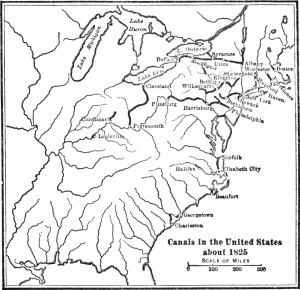
Canals

Stole a post from one of my older blogs, one on wordpress that I'd forgotten the password to.
Canal Building:

Then (1820s):

Now (2000s):


There are a lot of immense ruins dotting the Ohio landscape, some of them dating from the European settlement of the 18th and 19th centuries, some of them dating from the time of Christ. Many have been wiped out by agriculture or urban growth. Those that remain are for the most part off the beaten path or hidden from casual observers.

The canal system was a brief, but important stage in the infrastructure of Ohio. Only a decade or so after the last one was finished, railroads displaced them as the primary mode of transportation. However, the canals allowed migration and commerce to reach the landlocked central portions of the state, and connected the sea lanes of the Great Lakes with the Mississippi and Ohio rivers. As early as the 1780s, George Washington was mentioning the possiblity of using canals to facilitate the development of the Ohio country, in which he had been buying up land since the close of the French and Indian War. Perhaps he, as a young scout and militia officer, had heard of the great Indian portage trails linking the watersheds of rivers in central Ohio, which allowed navigation between the lakes and the Mississippi.

But it was not until the end of the War of 1812 that enough capital was available for such an ambitious undertaking, and the legislature finally got around to voting for the project in 1822, long after the wars were over and Washington dead. From the 1830s until the 1860s, canals were vital to the infrastructure of the state, allowing farmers to ship their goods without resorting to the horrible roads of the time.

Today, several museums interpret the history of the canal era and feature working canal boats and locks. Moreover, remnants of the locks, immense piles of limestone, still dot the countryside and lurk incongrously amidst modern suburbs.

Sunday, June 6, 2010

Cell Phone Pics

I use my cell phone camera quite a bit. Oftentimes it works simply as a memo pad, to record something I want to remember for later, like the title of an interesting looking book. Since I rarely bring a camera with me when I go places or travel, when I want to record a moment or an object, out comes my low-resolution camera. The pictures are usually pretty blurry, but at least its some kind of record of the subject.
(fig. a)
0512101020a
(fig. b)
0406091543a
(fig. c)
0409101642b
(fig. d)
0418101532a
(fig. e)
0425091650
(fig. f)
0422101651b
(fig. g)
0425091652
(fig. h)
0503101716a
(fig. i)
0507101326a
Fig. a: A small songbird found dead next to a cigarette. Smoking kills, kids.
Fig. b: Composition notebook found at the Blackburn House bus stop.
Fig. c: View of University Hall from the upper floors of the Thompson Library, OSU campus.
Fig. d: Geocache found in Westerville.
Fig. e: Graffiti on the GAR Monument at Fort Meigs, Perrysburg Ohio.
Fig. f: Display summarizing the economic geology of Ohio, Mendenhall Labs, OSU campus.
Fig. g: 5.5 inch howitzer, Fort Meigs.
Fig. h: Three officers of French Hussar Regiments, Osprey book.
Fig. i. Pan and lock of 1795 pattern Springfield Arsenal musket, before being cleaned.

Tuesday, June 1, 2010

Ohio Interurban Line

This is the text of a historical plaque in Canal Winchester, near Columbus Ohio:

Erected in 1905 by the Scioto Valley Traction Company, this station served as a terminal for passenger and freight service as part of an electric railway that connected Canal Winchester with neighboring towns in central Ohio. Known as the interurban, its arrival signaled the end of the gaslight era in the village. Regular service was maintained from 1904-1930 when improved roads and affordable automobiles rendered the system obsolete.

This historical marker stands in the original path of the interurban track that once ran parallel to the station along the north side of the Ohio and Erie Canal. Direct current from the "third rail" provided power to the interurban trolley cars to achieve speeds in excess of 60 miles per hour. Passengers could purchase a ticket to ride from here south to Lancaster or north to Columbus via Obetz Junction where a transfer could take travelers southwest as far as Chillicothe. (Accessed here).

It’s interesting how the idea of light rail for public transportation was successfully implemented over 100 years ago. Another prominent relic of the Interurban system is the Interurban Bridge at Roche de Boeuf  near Waterville, Ohio.

Tuesday, April 20, 2010

Places that I want to visit (part 1)

…But that are either impossible or difficult to visit.
800px-Temple_mount
Number one on the list would be the Temple Mount of Jerusalem. A lot of the violence and struggle between Muslims and Jews in the Middle East is due to this rocky hill. Why? Because the Jews once had a temple on top of it, that was destroyed several times. The Muslims have the rock, from which Muhammad ascended into heaven. Now the Muslims have a Dome of the Rock and a mosque  atop the hill. The Jews are not allowed to step foot on the hill, since they don’t know for sure where the Holy of Holies, the back room of the Temple, once was. Now they pray at the exposed retaining wall at the base of the hill. That’s a brief summary of a complicated and tense arrangement.

Why do I want to go there? Because apparently there are a bunch of tunnels and secret passages beneath the Temple Mount, with much speculation as to what might have been stashed away down there. Excavation of the area is frowned upon, because one party or the other might try to blow up the others’ holy site. It’s really a pity, because of all the archeological information that must be left up there. They probably didn’t stash the Ark of the Covenant down there, since Jerusalem was sacked several times, and the Ark was probably hauled off by someone or other.

411px-The_rock_of_the_Dome_of_the_Rock_Corrected.JPG

The Foundation Stone beneath the Dome of the Rock has a hole in it, which leads down to a cavern called the Well of Souls. I find that to be irresistibly intriguing. However, the same condition that lends this place its mystique, that of being a sacred space, makes detailed excavations and surveys politically impossible.

HMSTerrorThrownUpByIce

Number Two on my list is the wreck of the HMS Terror. In 1845 the converted bomb ship (a reinforced bombardment craft) was sent along with her sister ship, the Erebus (bomb ships were named after volcanoes), into the arctic circle to try and find a way from the Atlantic to the Pacific Ocean, via the Northwest Passage. They got about halfway through, and then were never heard from again. A note dating from 1848 said that John Franklin, the commander of the expedition, and 23 men had died and that the rest were abandoning the ships and trying to make their way south across the ice.  There were no survivors, and search parties had to piece together what happened from the bones and debris left by the expedition. The Terror has never been found, and marine archeologists suspect that she is lying intact on the ocean floor, preserved by the frigid waters that doomed her crew.

To visit such a ship would be like stepping into a time machine. In the 1980s an expedition exhumed some of the crew who had died early on in the voyage, and there is something eerie about looking at their photographs: the corpses still have their eyes, skin color, and clothes perfectly preserved. If either of the ships were ever found, who knows but that more of the crew might be still aboard, and could tell us more about their mysterious fate.

tunnel_title

Number Three, like Two, could be considered an artifact or a place, depending on your point of view. In the 1980s, a New Yorker named Bob Diamond rediscovered the first subway tunnel ever built under New York City, dating back to 1844. Ever since then, speculation has persisted that there may be an early steam locomotive and carriages buried in the unexcavated portions of the tunnel. I think the notion of a intact train, lying forgotten on its siding under bustling city streets, beckons the imagination.

channel_tunnel15

Number Four is a different tunnel, built in 1880 as an attempt to link England with France under the English Channel. 108 years later, the crews working on the Chunnel happened upon this earlier channel tunnel, which extended 3/4 of a mile beneath the sea. This forgotten space, a path to nowhere, has since been sealed off and flooded.

Wednesday, April 7, 2010

Mile Markers

Last Mile Marker "P 1 m"

Another face of the same marker, "LS 30 m"

The highway that runs from Perrysburg (south of Toledo, Ohio) to Fremont (south of Sandusky, Ohio) is state route 20, the Fremont Pike. Frequent travelers along this road might occasionally notice squat, triangular stones along the side of the modern roadway, that look somewhat like lonely tombstones. These stones are the remaining mile markers that trace the old turnpike between the village of Perrysburg and the settlement of Lower Sandusky (Fremont) (which grew up around the old fort where Major George Croghan and 160 men from the 17th Infantry Regiment defied an entire British expeditionary force). In the old days, this route cut directly through the Great Black Swamp of Northwest Ohio, and was known as the worst road in America. Given that most early American roads were actually little more than muddy tracks, this was a dubious honor indeed. Since in many places the swamp was ankle or waist deep, trees had to be felled across the road bed to create a passable trail for carriages and wagons. Nevertheless, the going was so slow for most travelers that enterprising locals created inns along the way: according to one source, at one time there were 32 inns spaced along the 31 miles separating Perrysburg from  Lower Sandusky. The milestones were set in place in 1842, once the road had been improved.

According to a brochure produced by the Woodville Historical Society,  of the 30 original milestones, 23 of them are still in place, and the remaining 7 were recreated with concrete replicas. This stretch of State Route 20 is the only one left in the United States with a continuous string of milestones, once a common sight for travelers.